Underground Utility Mapping Specialists
We are a California-based company specializing in GPS & GIS services. In other words, we are a mapping company. Our staff has over 12 years of experience with GIS and GPS technology. We can assist with project management, data conversion, data collection and map production.
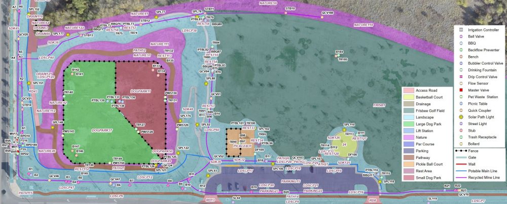
Our main service is utility mapping. This includes GPS data collection, data conversion and/or map publishing. This service can be used for old ( in ground) and new utilities.

underground utilities marking
Once subsurface utilities are marked ( usually done through Dig Alert/ Subsurface Utilities Engineering companies) we are called to capture the location of the identified utilities and provide a digital version of the marked utilities.
Advantages of mapping subsurface/above ground utilities include:
- access location data at any time. Ideally, this is part of the planning phase for all utilities to be installed (new)
- allow identified utilities to be merged with additional design documents and / or overlaying of the data with various GIS/CAD layers ( like aerial/satellite imagery, topo lines, other facilities, parcels,…)
- maintain an inventory of all on-site infrastructure

Methodology: professional equipment handled by experienced users
We are using GPS for capturing location of underground/above ground utilities ( water, electric, gas, phone, cable…) . Usually, captured data gets stored in a database but it can also be used to create PDF files ( capable of displaying Lat/Long as well as actual measurements ( distance, area) . Once location is collected, it can be overlaid on top of newer imagery ( as it becomes available) and /or can be used when planning/designing various projects on the specific site.
Delivery time frame:same/next day.
Deliverables: GIS,CAD or Google compatible data, geo-enabled PDF.

GPS data becomes GIS layers
We can also assist with creating site plans / event maps – usually needed for event coordination, commercial buildings, schools, government sites, etc. These maps will be used by admin staff but are usually the first item requested by emergency personnel when responding.
Sample mapping projects:
– Capture Utilities: water and gas pipes, electrical and communication lines;
– Capture Irrigation info: pipes, sprinklers, valves, controllers, irrigated areas;
– Site plans: buildings, evacuation points, emergency info, fire hydrants , chemical storage areas….
-Community / HOA maps: show boundaries, lots and horse trials or other appurtenances
What’s your project? We’d love to hear from you…even if your project is not mentioned in the list above ! We take pride in what we do and are ready to help.
Contact info: contact [at] advanced-map.com